Day 34 – Margaret
River – 42 km
Today is our wedding anniversary – 12 years! To celebrate,
we had a late morning, then pottered around a bit before getting dressed up
(well, decent clothes instead of travelling clothes) to go into Margaret River
for lunch. We ended up at the Margaret River Hotel, which had normal pub grub,
but also some other restaurant-style meals.
After lunch, Les had decided that he would treat himself and
buy some of the nougat from the Bettenay Nougat shop, so we went back there.
The deal was that if you bought 4 you would get another one free. We now have 5
bars of nougat!
 |
| We have trained our Kids to read the maps and give us the directions each day! |
Day 35 – Margaret
River to Northcliffe -257 km
Back to being a miserable old day – cloud, and threatening
rain.
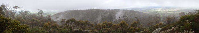
Today we drove south and east toward Pemberton. First stop
was at Beedelup Falls, where we went for a walk to the falls (many photos
taken). The big challenge was that the walk involved a suspension bridge, where
the best views of the falls were from the middle of the bridge. Les had to
decide which was stronger – his fear of heights or his need to take photos of
waterfalls. The waterfall won.


 |
| Police Radar in WA!!! Fools them every time. |
We then headed off to drive through the karri forest that is
Warren National Park. We stopped to take photos at Marianne North Tree – named
after an artist who did a painting of it – and the Dave Evans Bicentennial Tree
– an enormous tree that is one of the three huge trees in this area that can be
climbed. Neither of us is brave enough to climb the tree – the climb is 65
metres straight up, on iron pegs nailed into the tree, so no way could we do
it. We did pretend, though.
 |
| Marianne North Tree |
 |
| Dave Evans Bicentennial Tree |
 |
| Dave Evans Bicentennial Tree with Joy in the white top at the base |
Once we had “done” the trees, we continued on to – yes,
another waterfall! Well, there haven’t been many waterfalls before now so it’s
only fair that Les gets to see these. This wasn’t actually a waterfall, but
cascades – called Cascades, in fact.
 |
| Cascades |
 |
| Red Breasted Robin |
By this time, the rain was starting to be a nuisance, but we
still went down to D’Entrecasteaux National Park, actually, to Point
D’Entrecasteaux. We stopped at the lookouts, took photos, and did the walk we
wanted to do, even though it was cold, wet and windy (well, windy whenever we
were close to the cliffs). We saw Nature’s Window, which was quite impressive.
I wonder how many Nature’s Windows there are in Australia?

 |
| Nature’s Window |
On the way back, we called in to Salmon Beach and were lucky
enough to see whales! They were quite a way out to sea, but we could still see
them quite well with the binoculars. There were some big splashes from leaps
and slapping, but mostly just pffts of air.
Our accommodation for tonight is a cabin right in the bush.
As I type this, I’m starting to get annoyed by the noise the frogs are making!
Day 36 –
Northcliffe to William Bay – 191 km
Woke to sunshine today after heavy rain during the night. As
it was such a nice morning we sat on the verandah to have breakfast.
 |
| View from cabin where we had breakfast |
We headed into Northcliffe and did a walk through the
“Understory” which is a sculpture park in the bush. Some of the sculptures were
interesting and some were just weird.
 |
| Understory |
 |
| What a name!!!!!! |
We then travelled through the Shannon
National Park with many large trees, or that should be HUGE trees. When we were
heading to the highway and campground to have morning tea we came across a car
parked sideways across the road and a tow truck in front of the car. They told
us the car had slid off the road into the bushes and they had just finished
extracting it.


Next stop – Fernhook Falls. The river here is tea coloured
from the tannin in the forest. There was a lot of foam from the waterfall all
over the river.
 |
| Fernhook Falls |
 |
| Fernhook Falls |
After lunch & shopping
in Walpole we went to Valley of the Giants / Tree Top Walk. We started
the Tree Top Walk and when we got to the metal walkway that had a grate floor
and wobbled, that was enough for Les so he turned around and went to where the
walkway finished and waited for Joy. She said it was a good idea as the walk is
very high (up to 40 metres) and it swayed and wobbled even more than the
suspension bridge from yesterday!!

We then did the Ancient Kingdom (which is
all at ground level) and while doing this walk met the people from the car that
had run off the road in the forest.

After talking to them (one was on a
sabbatical studying sandflies) they explained that they got too close to the
edge of the road and slipped over the edge. It was the 2nd vehicle in a week to
do this. Being Canadian they were driving further to the left than normal as he
had only been in Australia for a few days.
Headed to William Bay and settled into our very comfortable
accommodation – a cabin in the bush.
 |
| William Bay Cottage |
Day 37 – Giant
Tingle Tree, Circular Pool, Mt Frankland, Swarbrick, Conspicuous Cliff – 208 km
Had breakfast outside since it was a nice morning. Sadly the
little birds didn’t come close enough or stay long enough for us to take photos
– but at least we saw them so we know they are there.
First stop was Hilltop Lookout on the way up to the Giant
Tingle Tree north of Walpole. The lookout is over the forest toward the
coastline, and is okay, but nothing spectacular. The Giant Tingle Tree,
however, is quite impressive. The national parks have built a boardwalk there
so the trees are not damaged by all the visitors, but you can still get up
close to the trees – in fact you can walk into them! There is a Giant Tingle
Tree and a Big Tingle Tree – both are impressive.

Further along the road we stopped at Circular Pool. This is
a pool that is created along the river – apparently in the right conditions it
looks like the water goes around and around the pool, so it isn’t called
Circular Pool because of its shape! At the moment, there is a LOT of water
going down the river.
 |
| Circular Pool |
We then drove along to Mt Frankland. We weren’t sure if we
were going to do the full walk there as it goes right to the top and involves
ladders and more than 300 steps. While we thought about it, we had lunch, and
then decided that we were there, so we may as well give it a go. In the end, we
were glad we did, since the scenery was lovely, and the view from the top went
forever. Mt Frankland is an enormous granite (I think) rock and was steep and
it was very windy.
 |
| Stairs to Mt Frankland |
 |
| View from Mt Frankland |
On the way back from Mt Frankland we stopped at a place
called Swarbrick. This is an art installation in the middle of the bush. When
we got there, we heard a big bang, or something hitting something metal. As we
went down towards the start of the walk, we heard it again. Turns out the first
piece of art is a 39 metre long mirror with some etchings on it, and a bird
must have thought it had seen a threatening bird in the mirror (ie itself) and
had attacked it!

There were several sculptures around the walk – some were interesting,
others were not. At least with this one it was free to do the walk, not like at
Northcliffe where it cost $11 each!
We stopped in to Conspicuous Cliff and Peaceful Bay on the
way home. At Conspicuous Cliff, we did the walk out to the whale watching
platform. We took photos of the view, since the whales weren’t showing
themselves. Just as we were about to leave, Joy spotted a big splash way out to
sea. On checking with the binoculars, it was confirmed as a whale, doing a few
leaps, but then it went quiet.
 |
| Conspicuous Cliff |
 |
| Les' Artistic Photos!! |
Along the roads to Conspicuous Cliff and Peaceful Bay, we
had to stop a few times to take photos of flowers – we are still finding ones
we haven’t seen before!
Day 38 –
Torndirrup National Park, Whale World – 207 km
Woke to another glorious morning, with just a few clouds
hanging around. This time we headed east
to Torndirrup National Park. The first stop was at “Sharp Point”. It is basically
a bush track and we nearly missed the turn off. But are we glad we found it.
The view from the lookout was spectacular. Wind farm to the right all the way
around to the islands off to the left and the lighthouse. There were also more
flowers to photograph!!
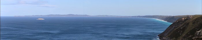 |
| Sharp Point |
 |
| Sharp Point |
Next stop – “the Gap and Natural Bridge”. I wonder how many
“Natural Bridges” there are in Australia and the world!! Again more spectacular
scenery but no wildflowers as it was all rock. The Natural Bridge looks like it
could fall down any minute due to the cracks in the rocks on the “bridge” but
we have seen photos with people standing on it. No Brain – No Pain. The Gap is
an impressive gap / bay in the rocks where the waves pound in and create spray.
The seas were fairly mild today, even though there were a lot of white caps
which made whale spotting almost impossible.
 |
| Natural Bridge |
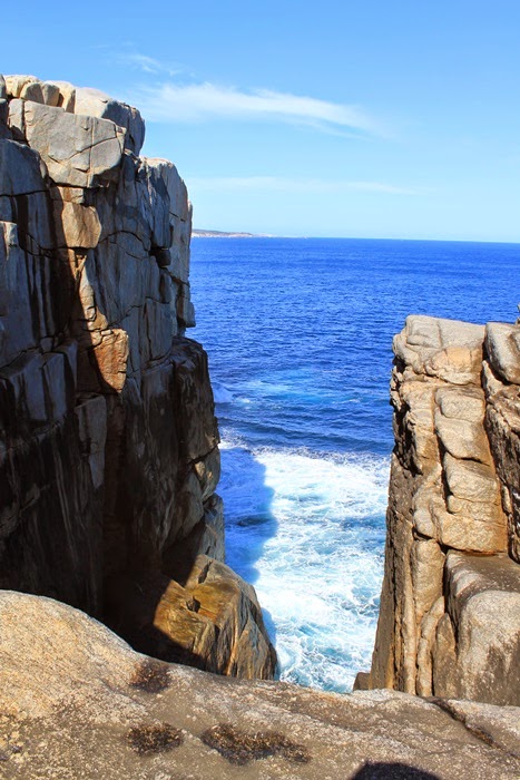 |
| The Gap |
We then headed down to Cable Beach,
 |
| Cable Beach |
and then on to the
“Blowholes”, which were not blowing today as the sea was so calm. When we finally
reached the Blowholes, they are only very small holes in the rocks and other than
a bit of noise were not very impressive, especially with the walk back being
almost all uphill. But we did get to see some divers and more coastline and
wildflowers.
 |
| Blowholes |
 |
| Divers at Blowholes |
 |
| Stairs on way back from Blowholes |
By now we were warm and hungry so headed to Frenchman Bay where
we had lunch looking out over the bay while sitting at a picnic table in the
shade. Beautiful!!
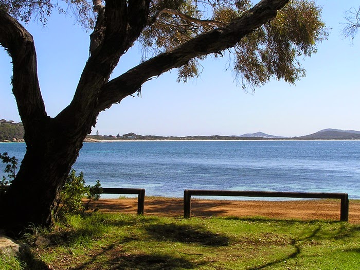 |
| Frenchman Bay |
After lunch we headed to Whale World where we did the guided
tour. Worth a visit (although cost $29 pp) even if you are against whale
hunting as we both are. The tour and video goes for about an hour (Joy watched
the 3D whale video and Les watched the 2d shark video) and we then did a walk
through the whaling ship they have there. Interesting to see who had their own
cabins and who had to share.
 |
| They have VERY large Kangaroo Paws in WA |
 |
| Whaling Boat |
 |
| Pygmy Blue Whale Skeleton |
Quick trip to the lookout at Salmon Holes, followed by a
walk at Stony Hills which had some impressive rock formations and some more
wildflowers. Last lookout was Newells Harbour.
Day 39 –
Sandalwood Factory, Porongurup National Park – 231 km
Woke to another fine day, even though there was a severe
weather warning for the area. After breakfast the wind started to pick up but
still fine weather so we headed east again.
 |
| Yes it was windy!!!! |
Mt Romance Sandalwood Factory is
where they distil the Sandalwood tree to make the oil. The trees are
interesting in that they have to be grown with host trees that they use to gain
their nutrients and water from. There are 2 types of Sandalwood trees, the
Australian and the Indian and they grow mostly the Indian as it grows much
faster and they can extract more oil. The trees, which they are growing in
several places in Northern Australia, are harvested when they are about 25
years old and the bulk of the tree is actually the roots. A mature tree will
weigh about 1 ½ tonnes and this will (after 5 to 7 days of cooking) produce
about 23 litres of the first pass sandalwood oil, which is the best quality oil.
The current value is about $100,000.00. The remainder of the tree after this
process is used to make more 2nd grade oil for things like soaps and
candles. What’s left after that is then sent overseas where they make
sandalwood incense sticks which are used in many religious ceremonies. In fact
the entire tree is used and there is no waste at all. BUT what is the main use
of the first pass oil – the base ingredient of perfumes including Chanel No 5
and Red Door (I’m sure the ladies will know these!).
On to Porongurup National Park and the walk to Castle Rock
walk but by now the weather had turned windy and showery but we are tough so we
headed off with wet weather gear. The walk is 2.2 km all uphill!! And when I
say uphill, I mean all uphill. We think there was about 30 metres of roughly
flat ground but that was it. We had showers and rain during the climb to the
top but we were just as wet from sweat as from rain. When you get to the top
there is a Balancing Rock and a lookout. You can also climb between some rocks
and up a ladder to a long suspended viewing platform. As it was wet and very
windy we did not go to the very top but went out to the smaller viewing
platform. We were lucky as the fog cleared a few times to give us a view to the
farmlands below. There was a couple waiting at the top that had been there for
½ hour waiting for the fog to clear!!
 |
| Porongurup National Park |
 |
| Porongurup National Park |
.JPG) |
| Suspended Walkway, Castle Rock, Porongurup National Park |
 |
| Stirling Ranges from Porongurup National Park |
 |
| Balancing Rock, Porongurup National Park |
Normally coming back down is easier (well for Les anyway as
Joy has worn out knees) but because it was constant downhill and fairly steep
you had to be holding yourself back all the time so we both were very weary by
the time we reached the car park at the bottom. It had taken us 2 hours to go
up and back which included 20 minutes at the top. The next walk we planned was
about 1 km but we decided to give it a miss as it was raining heavily now and
drove back to the cottage arriving at about 3:30.
 |
| Duck and Ducklings at William Bay Cottages |
Day 40 – William
Bay – Greens Pool – Elephant Rocks - 55 km
Today we had just a short drive to the nearby William Bay
National Park to have a look at some more coastal scenery. We had seen there was a
Toffee/Cider/Sauce/Olive Factory down the road that advertised it had coffee
and food so decided to try it for morning tea. What a mistake! The coffee came
out of a machine and they had the hide to charge $4.00 for a coffee in a paper
cup!! The toffee we tried was nice but all too expensive. So we headed to
Denmark for morning tea and tried Mrs Jones Café. We are finding that the cafés
in Denmark are quick to take orders and slow to provide the food/drink. Also
they are expensive.
After morning tea we headed to William Bay National Park.
First stop was Greens Pool which would be beautiful on a summer’s day but today
with wind, cloud, rain and high seas it was interesting but not great.
 |
| Greens Pool |
Next stop was Waterfall Beach where there is a waterfall
that falls from the hill direct onto the beach.
As we had only taken Les’ little camera we did not stay as long as we
would have if he had his tripod and other camera, but also it started to rain
and the tide was also a problem.
 |
| Waterfall Beach |
Last stop was Elephant Rocks and even Joy
could see the outline of the Elephants here. Again the showers started so we
headed form home.
 |
| Elephant Rocks |
 |
| Elephant Rocks |
Day 41 – William
Bay to Hopetoun – 461 km
After a night with heavy rainfall overnight we woke to
sunshine, followed by rain, hail, wind, sunshine, etc.


We headed north towards
Stirling Range National Park and the weather has turned for the worse again
with rain and wind. As we got closer to Stirling Range the rain stopped but the
wind was getting worse. We turned off the main road and before we even reached
the National Park we had come across more flowers that we had not seen before.
Imagine what it will be like when we get in the park!!.
First stop was at Red Gum Springs, then off on the Stirling
Range Drive which is a 42 km drive down the centre of the range. What can we
say but WOW!!! What scenery.


We stopped at the West Lookout and took photos of
the view and wildflowers. Them in the next 1 km we stopped about 6 or 7 times
to photograph more wildflowers and some scenery.

We stopped at Central Lookout
and took more wildflower photos and a few scenery photos. A few more stops
before we arrived at the sealed road at the end of the Stirling Range Drive.
Next we headed up to Bluff Knoll.

 |
| Bluff Noll |
We had lunch in the car looking at this magnificent
view. You can walk to the top but it is over 6 km return and the suggested time
is 3 – 4 hours. One of the others in the car park said they had spoken to some
people that had just finished the walk and up on top it was bitterly cold and they
could not feel their fingers.
Day 42 – Hopetoun
to Esperance – 303 km
Woke to a sunny day but
the wind however picked up again. But that doesn’t stop us, so we headed into
the Fitzgerald River National Park. Stopped at Barrens Lookout which has views
over the ocean and inlet/lake, as well as the impressive hill behind us.

The
wind had really picked up by now and it was sometimes difficult to even walk in
a straight line.

 |
The next stop was Sepulcris Hill and the short walk to the
top. This hill is fairly low so the walk is easy other than the rocky track. On
the way down to Four Mile Beach saw a Yellow Bellied Black Snake crossing the
road.

Headed towards Esperance and regularly stopped to take
photos of wildflowers along the way. Lunch stop was at Stokes National Park
sitting at a picnic table looking out over the water. Beautiful!
 |
| Stokes National Park |
Near Esperance we headed south to do a drive along the coast
via Pink Lake which is not normally pink and was not pink today. Then hit the
coast at 10 Mile Lagoon. The lagoon is not 10 miles long but is 10 miles from
Esperance. We also went to the Wind farm and surprisingly we were able to walk
right up to and touch the actual turbine. We continued towards Esperance and
stopped at Observatory Point for a walk to the top of the stairs at the point.

We clocked up 10,000 km for the trip today!!

Day 43 – Cape Le
Grand, Cape Arid, Duke of Orleans Bay - 358 km
When we woke this morning, there wasn’t much wind, and it
was a bit sunny, but by the time we left for our day trip, it had clouded over
completely and the wind had picked up. Oh, well, that won’t stop us!
First stop was Cape Le Grand National Park. This time we at
least waited until we were in the National Park before we stopped along the
side of the road to take photos. The landscape is low and flat, with scrubby
bushes and stunted trees scattered throughout. It was very windy today, and I
think that is fairly normal for here, based on the trees and bushes. We are
still finding new plants and flowers that we haven’t seen before. One of us
will see something as we drive past, so we stop to have a look, then when we
get out and have a look around, there are HEAPS more things to look at.
We also had to stop along the way to take photos of the
hills/mountains – they are huge granite things and look pretty spectacular.
Frenchman’s Peak is interesting, too, because there is a formation at the top
of it that means there is a hole right through it.
 |
| Frenchman's Peak |
The fellow who checked us in at the motel in Esperance
recommended Lucky Bay as a good spot for wildflowers. So we stopped, and yes,
there were wildflowers. The view was very good, too. We just love this sort of
coastline – lots of granite rocks, and big ones at that, with the surf pounding
in.
 |
| Lucky Bay |
After Lucky Bay, we went around to the next bay – Thistle
Cove. There is a Whistling Rock here, and it does whistle, but in the same way
as other whistling rocks we have seen – ie it is a bit of a whooshing sound
rather than a whistle. Still, the rock formations here are very interesting,
and great waves pounding.

 |
| Whistling Rock (large rock at right hand back) at Thistle Bay |
Then it was out to Cape Arid. The road to Cape Arid is a lot
of dirt, and mostly it is good dirt, but once we got into the park and headed
to Thomas River, it became very rough. It wasn’t as bad as the road to Nature’s
Window in Kalbarri National Park, but it wasn’t a comfortable ride. After
having lunch we went to Dolphin Cove, where we had been told there were whales.
Above the cove there is a lookout, so we stopped there as we weren’t sure what
would be down at the cove itself. Joy got out to the lookout first and was
looking for the whales when she realised that what she had thought was a rock
shelf under the water close to the shore was actually a whale – her reaction
was “Oh my God!” as she just couldn’t believe how close the whale was. Les then
made it down to the lookout, and his reaction, once he realised the dark shape
under the water wasn’t a rock shelf or seaweed, was “Oh my God!”. We then
realised it was a mother whale and her calf. Quite a few photos and some movies
later, we got back into the car and drove down to the parking area at Dolphin
Cove. We walked along the trail for a short while and came to a rock shelf
where we were able to watch the whales from what we would guess would be no
more than 100m away. It was absolutely amazing! We never thought we would be so
close to a whale. We stayed there for quite some time, then realised we should
head back so we would get back to Esperance before dark.
 |
| Les and the Whales, how close can you get |


 |
| Dolphin Cove, Cape Arid National Park with Whales in water at left |


We did stop for a break at Duke of Orleans Bay, as we had
been told it was worth looking at. And yes, it was good scenery, but the
weather by then was windy and a bit wet, so we didn’t see it at its best.
 |
| Table Island, Duke of Orleans |
 |
| Road home from Cape Arid with large puddles along the side of the road. |
We can now definitely say that we are NOT grey nomads. To be
a true grey nomad, you have to be towing a caravan, preferably with your names
and CB radio channel printed on it, and taking photos with an iPad. Usually the
woman carries the iPad, and if the man carries anything it will be a
fancy-pants camera with lots of bells and whistles.
A couple of the local characters we have met!!


A few more flowers we have seen (just a few of the many!!!!)


I managed to walk the Valley of the Giants walkway, but only if I looked down and ahead about 5m. This meant I could not see through the grating, nor up enough to get vertigo. I thought I would be safe at the pylons where the path changed direction, but turns out they sway in the breeze as well! Not helped when a young boy thought it would be fun to rock it back & forth like a swing!
ReplyDeleteSeeing as you are looking at lots of rocks, did you see Dog Rock in Albany?
Looks amazing - such wonderful scenery. David climbed one of the trees with the pegs. Said it was a great view at the top - I didn't even think about going up as I knew it would not be a good thing!!
ReplyDeleteFantastic pics. The coast line and the national parks look so rugged and beautiful maybe even more so in the rain and mist. I remember when I went to Stirling Ranges NP we kept stopping on the road to take heaps of pics of the view - it is stunning and I still have a couple of range skyline in a picture frame on the wall. Good on Les for letting the waterfalls win!
ReplyDeleteTwelve years and 10,000 kms - two great milestones!
ReplyDeleteAnne W xx